Les flâneuses®

Les flâneuses®

D70-A

#universal accessibility #public reception area #universal mobility #design for all #social innovation

about us :

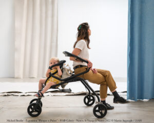
Les flâneuses® provide establishments open to the public with a tailor-made universal mobility service. This offer enables them to transform accessibility constraints into a new, fun and inclusive mobility experience. All the while promoting public and low-carbon transport.

When it comes to the last kilometre of travel in large establishments, the flâneuses® are an obvious complementary link in the mobility chain. Universal, they are a range of patented micro-vehicles that support the autonomous movement of the public. They can be used without distinction to carry belongings or to support, sit on and carry several children. For some visitors they are a comfort, for others… they are an essential.

The strollers already accompany more than 500,000 users through a hundred or so sites. Among the best known are the Louvre Museum, Paris airports and some of the world’s largest aquariums, zoos and amusement parks. The benefits measured are

– Improved comfort
– Longer visits
– Increased visitor loyalty
– Increased shopping basket
– Easier access for visitors with special needs
– A reduction in the cost of human support (PHMR)
– The creation of recurring income through rental

Present in the Louvre and 50 other museums, the original model les flâneuses® is the fruit of 3 years of R&D with 250 people to achieve the obvious simplicity that is the strength of universal design. Stored and sold in packs of 10.

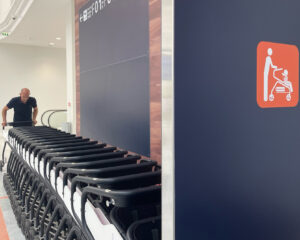
Chosen by Paris Airports to accompany the first steps of visitors from all over the world during the 2024 Olympic Games, the Airport flâneuses® model is a concentrate of engineering. Stored, sold and movable in batch.

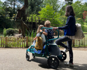
Here’s the latest exclusive… After several months of testing in major theme parks and UNESCO sites, this outdoor model of les flâneuses® is even more fun and eco-designed. A serious UX tool for your visitors.

CONTACT US

Thérèse DonnetSales Director
E-mail : contact@lesflaneuses.com
therese.donnet @lesflaneuses.com
Tél. : 06 32 72 51 51

42 avenue du général de Croutte – 31100 Toulouse – France

Website : Les flaneuses

WaltR

WaltR

D70-A

#AirQuality #ClimateChange #Imagery #Emission #Space #AI

about us :

WaltR, a pioneering player in monitoring pollutant emissions through spatial imaging (CNES patent)
and ground monitoring, enables its clients to monitor and reduce their impact on air pollution
and climate by objectifying their environmental performance and prioritizing corrective actions
that incorporate constantly evolving regulatory, social and economic criteria.
 
Based in Toulouse and Nantes, WaltR utilizes spatial technology coupled with AI to precisely
identify, measure, and map gas and particulate pollutant emissions in cities, industrial sites, and
airport or port infrastructures.
 
WaltR also supports its clients through the change management with guidance provided by a social and environmental psychologist.
 
With a high-level international team of 20 people, WaltR aims to become a leading independent
European provider of emission monitoring and a key supplier of spatial data for businesses and
public entities committed to ecological transition policies, socially responsible investments, and
corporate social responsibility.

Global Emission Monitoring – Dynamic real-time mapping of air pollution and GHG emissions & main sources hot spot tracking

Environmental Score – Indicators using satellites imagery

A platform to guide and enhance the political actions of the cities in favor of the environment and climate through dynamic and objective satellite-based measurement of environmental indicators

CONTACT US

Arnaud DEDIEU / Marion MOREIRACo-founder, Business Development Director / R&D and CSR Project Manager
E-mail : contact@waltr.fr
arnaud.dedieu@waltr.fr / marion.moreira@waltr.fr
Tél. : 06 73 73 71 92 /07 66 17 45 06

Parc Technologique du Canal – 14 avenue de l’Europe
31520 Ramonville Saint-Agne- France

Website : Waltr

THE CLIMATE COMPANY

THE CLIMATE COMPANY

D70-A

#ClimateRisks #ClimateAdaptation #UrbanClimateIndeX #UrbanBotanix # Cities&Climates #UrbanSimulation

about us :

The Climate Company is committed to accelerating the ability of cities to adapt to climate change and contributing to the preservation of infrastructure and all public and private real estate assets that make up urban areas.
To achieve these goals, The Climate Company develops scientific & technological solutions that enable all city stakeholders, whether from the public or private sectors to anticipate exposure to climate risks on an urban micro-scale, in short and medium terms, and to assess the intensity and frequency of associated risks and to simulate the effectiveness of the proposed solutions.
The Climate Company combines scientific expertise, acute knowledge of climate dynamics, aerospace observation technologies and statistical analysis at the service of the resilience of cities to climate variability and change which apply to many sectors.
The UCIX – Urban Climate IndeX-, developed by The Climate Company allows to evaluate the exposure to climate risks of a city, at neighborhood or building levels. The UCIX is automatically calculated from a simple address or GPS points anywhere in the world.

Cities & Climates – The Internet of Climate for cities

Cities & Climates is a virtual platform making available, in a secure environment, all climate assessments calculated by The Climate Company, including the UCIX for all the districts of a city.

Urban Botanix – A solution to urban climate change

Urban Botanix allows cities to identify urban areas suitable for planting trees, to design revegetation programs and to choose the most adapted trees species to face identified climate risks.

Urban Simulation – Urban climate modeling

Urban Simulation aims at assessing the climate impact of construction projects in urban areas. It allows considering different scenarios to select the most efficient one to adapt to future climate risks.

CONTACT US

Laurent HussonPresident
E-mail : husson@theclimatecompany.eu
Tél. : 06.43.93.72.39

7 rue Clémence Isaure – 31000 Toulouse – France

Website : The climate company

LTU Tech

LTU Tech

D70-A

#Computer Vision #Environment #Satellite #Remote Sensing #Change Detection #AI

about us :

LTU is committed to harnessing the power of unsupervised artificial intelligence algorithms and computer vision technologies to enable a sustainable and climate-resilient future. Our mission is to provide cutting-edge solutions that help prevent and mitigate the effects of climate change, reduce environmental risks, and safeguard the planet for future generations. Through the analysis of satellite imagery and remote sensing data, we aim to empower governments and communities with clear actionable insights to make informed decisions and proactively respond to environmental challenges.

In a world where the urgency of climate change is undeniable, LTU stands as a unique and indispensable player in the market. Traditional deep learning models require vast amounts of labelled data and struggle with the irregular changes seen in spatial remote sensing. LTU leverages unsupervised artificial intelligence algorithms that allow us to provide immediate operability, adapting to the inherent variability of satellite imagery, including factors like cloud cover and weather conditions, while maintaining high detection accuracy. Thus, in industries where rapid data capture and transmission are vital, such as environmental monitoring, LTU’s approach offers efficient, flexible, and cost-effective remote sensing change detection. This ensures that our customers have a competitive edge, enabling them to make real-time decisions that protect their interests and the environment.

Our mission: Empower stakeholders and organizations to provide insights and mitigate the effects of climate change, reduce environmental risks, and protect critical resources through advanced satellite imagery analysis and technology.

LTU’s EarthChange leverages open data satellite images for natural risk management monitoring and assets surveillance. Present use cases relate to urban planning and water networks monitoring. Alerts are generated through change detection algorithms.

LTU’s solutions for monitoring climate change impacts and for water leaks detection combine satellite imagery analysis and proprietary frugal algorithms to help its customers for climate change and asset management risk assessments purposes

CONTACT US

Olivier GravetCEO
E-mail : ogravet@ltutech.com
Tél. : + 33 6 20 81 87 92

31 allées Jules Guesde – 31000 Toulouse – France

Website : LTUtech

I-SEA

I-SEA

D70-A

#ClimateRisks #ClimateAdaptation #Biodiversité #Littoral #space #AI

about us :

I-SEA provides modern solutions at the crossroads of space and digital for the coastline and biodiversity. It offers a differentiating offer on the cartography and monitoring market produced by experts in biodiversity and oceanography. The co-founders are two women that are passionate about the benefits of space and the added value that satellite imagery brings to the detailed and precise knowledge of our territories and of our ecosystem.

I-SEA offers a service dedicated to the challenges of Biodiversity to support the implementation of public policies in favor of the reconquest of Biodiversity, ecological and climatic transition.

Space data are essential for monitoring the mobility of the coastline, the evolution of the bathymetry of shallow waters and shore bars, characterizing the evolution of sedimentary stocks, and assessing the vulnerability of coastal areas to coastal erosion.

I-sea has also invented a new offer to support clients and maritime works operators in managing their water quality issues and controlling the impacts of dredging and dumping activities on the marine environment.

Finally, I-sea proposes an offer allowing better knowledge of the nautical sector on bodies of water (counting of boats, areas of navigation and periods of frequentation, anchoring areas, activities practiced) and therefore the pressure exerted on marine habitats.
 

The satellite tool BIOCAST provides a precise and up-to-date overview of the different types of vegetation and natural habitats. It allows the very high-resolution ecological characterization of natural spaces and natural spaces in the city.

Our generic coastline product is a monitoring tool for the dynamics of the shoreline which allows a rapid and global diagnosis of the recent evolution of the coastline. The interest lies in its global coverage and reproducibility.

From satellite archives, it is possible to reconstruct a historical database of certain water quality parameters (turbidity, concentrations of suspended matter, chlorophyll-a, etc.) with a time depth of up to 20 years.

CONTACT US

Aurélie DehouckPresident
E-mail : aurelie.dehouck@i-sea.fr
Tél. : +33 06.17.18.25.33

Bâtiment Wood Office – 30, Avenue de Canteranne – 33600 Pessac – France

Website : I-Sea

SCALE by Aerospace Valley

SCALE by Aerospace Valley

D70-A

#Space #Climate-change #Sustainability #City #Resilience #UrbanPlanning

about us :

In the fight against climate change, space provides today data to monitor climate. Satellites allow scientists to observe the planet continuously and provide a range of geo-referenced environmental data at different scales (global, regional, local).

Space data is now a source of business for many companies. Since the establishment of the Copernicus program, which makes Earth Observation data available free of charge, a lot of private players have been able to transform the raw data produced by satellites into decision-making services useful for many application sectors such as the ecological transition.

Satellites have the advantage of providing recurring, global and time-monitored data that can be hybridized with complementary data (in-situ, IoT, socio-economic, …). This data fusion is facilitated by AI and Big Data technologies that make it possible to massively process this data and develop a multitude of operational services to support the climate action of public and private decision-makers at different stages: diagnosis, monitoring or assessment.

The areas of services are huge: resources (water, energy) management, urban planning, coastline, air quality, GHG emissions, natural risks (flood, drought, fire, storm, …), climate change, light pollution, infrastructures monitoring etc. and concern both the public sector (development and monitoring of public policies).

-Monitor city resilience at different levels (city, neighborhood, building): Land use, urban growth, natural risk, definition of areas to be urbanized, green spaces, public facilities etc

-Simulate city projects to evaluate the impacts

– Monitoring of pollutant concentrations in the air (including all GHG) or presence of fine particles

– Find source emissions (natural or human)

– Predict and alert of pollution episodes

– Evaluate the impact of environmental policies

– Monitoring of water resources, water quality (detect bloom algae or pollutant presence), coastline, heat islands

– Predict and alarm for floods, drought, fires, storms, landslides, earthquake

– Evaluate environmental policies impacts

CONTACT US

Sylvie TEYSSEYRESpace
E-mail : teysseyre@aerospace-valley.com
Tél. : 06 16 38 66 32

31400 Toulouse – France

Website : SCALE

QUCIT

QUCIT

D70-C

#bikesharing #optimization #software #operations #predictive #micromobility

about us :

Qucit is a Bordeaux-based software company founded in 2014 whose mission is to simplify shared mobility to make cities more pleasant, efficient and sustainable. We support bike-sharing operators to help them simplify their operations by optimizing the logistics of field operations.
The Qucit team includes 13 engineers, a sales team with strong expertise in shared mobility, an administrative and financial manager and a talented graphic designer.
As a leader in the logistical optimization of shared bike systems, our objectives are simple: to increase bike utilization rates, guarantee compliance with the service levels expected by local authorities, and reduce operating costs by simplifying team management and limiting energy consumption. Composed of a dashboard and a mobile application, Qucit Bike automates fleet rebalancing, bike collection, station maintenance and battery swap.
Today, Qucit Bike is used by operating teams on 3 continents and in over 30 cities worldwide (including Paris, Toronto, Barcelona, Singapore and Gdansk).

Rebalancing 

Qucit Bike allows to automatically optimize rebalancing operations to match your strategy and insure the availability of bikes, reduce the kilometers traveled and increase the productivity of your operating agents.

Bike Charging Module 

Our « battery swap » option automates the movement of discharged electric bikes to charging stations and offers an « Intelligent E-bike Relocation » to complete the regular rebalancing tours.

Bike Collection 

Our « bike collection » option helps you achieve high levels of bikes and stations availability by automatically optimizing the pick-up tours for deactivated bikes and reduces the number of kilometers traveled during the operations.

CONTACT US

Mathilde FoucaudE-mail : communication@qucit.com
mathilde.foucaud@qucit.com
Tél. : +33 6 23 41 90 09 – +33 6 84 00 57 17

3 rue Michel Montaigne – 33000 Bordeaux – France

Website : Qucit

NEXIODE AGORA CONNECT

NEXIODE AGORA CONNECT

D70-G

#Street Lighting, #Smart Cities, #IOT solutions, #Energymanagement, #Zhaga, #NEMA

about us :

NEXIODE AC has a strong experience in the field of wireless technologies for more than 15 years with a dedicated R&D center for product development. 
We specialize in smart lighting solutions, offering complete solution from Smart Controllers and Sensors to software management platform to address lighting and energy optimization needs for Smart Cities.

NEXIODE provides a full set of Smart Controller based on Zhaga, NEMA, pole mounted which are based on wireless standardized technologies as ZigBee, LoRa, cellular communication as LTE and NB-IOT.  

Our portfolio includes CMS software platform dedicated to Smart lighting & smart Cities management.

Based on our expertise of 20+ years in hardware and software development for home automation, lighting and industrial applications, our R&D team can customize products and solutions according to dedicated needs. Our skills are based on Hardware & embedded software, wireless protocol, IoT web development, Android & IOS apps.

CONTACT US

Olivier DENIEL /
Gary JACQUARD & SAJJAD SAFIR
CEO / International sales manager
E-mail : contact@nexiode.com
olivier.deniel@nexiode.fr / gary.jacquard@agoramakers.com/ safir.sajjad@nexiode.com
Tél. : +33 2 98 10 38 41

112 Boulevard de Créach Gwen – 29000 QUIMPER – France

Website : Nexiode

NETCARBON

NETCARBON

D70-C

#Carbon Storage #Urban Heat Island #Climate #Ecology #Satellite data #Artificial Intelligence

about us :

Netcarbon is a SaaS platform that fuses field and satellite data with artificial intelligence to support development stakeholders (local authorities and private companies) and agribusiness players in their ecological transition. Our mission is to help them reduce their carbon footprint and implement concrete actions in favor of the environment, thus meeting the expectations of citizens, investors and regulations in terms of sustainable development.

Our innovation lies in the creation of a carbon storage measurement algorithm, developed in partnership with INRAE, enabling our customers to accurately and efficiently measure and improve their carbon storage. Our customers can design a complete carbon storage strategy, from initial measurement to final certification:

1. Precise measurement: Our platform enables them to measure the state of their territory and understand where opportunities for improvement lie.
2. Improvement scenarios and simulation: We help them explore different improvement scenarios and simulate the impact of renaturation actions, to make the best decisions.
3. Continuous monitoring: Once projects are running, our platform ensures continuous monitoring of their progress, enabling our customers to adjust their strategies in real time.
4. Integrated certification: We facilitate the certification process via recognized labels (Label Bas Carbone or GhG Protocol).

Application Dashboard: The dashboard provides an overview of the current state of the area, including all indicators (Urban Heat Islands, Carbon Storage, Carbon Stock, Soil Classification, etc.). Here’s an example showing the city of Paris.

Simulation Feature: This section of the application allows for creating development scenarios and simulating the impact of actions implemented on our indicators. Here is an example of an eco-construction project simulation in the city of Anglet.

Label Certifications: This section showcases the certification process for the Low Carbon City Label. It verifies project eligibility and facilitates certification, all within the application.

CONTACT US

Adrien MazeauCo-founder
E-mail : contact@netcarbon.fr
adrien.mazeau@netcarbon.fr
Tél. : +33 6 08 90 86 22

2 Place de la Bourse – 33000 Bordeaux – France

Website : Netcarbon

ECOMETRIQUE

Ecométrique

D70-E

#micropolluants #water #passivesampling #data #training #monitoring

about us :

Ecométrique is at the forefront of environmental innovation, specializing in pollutant monitoring through passive sampling technologies. Our passive samplers, deployed in various water bodies (rivers, domestic and industrial wastewater) for periods of 5 to 15 days, accumulate pollutants over the entire deployment period. This method provides a precise and continuous picture of water quality, significantly improving environmental analyses.

We offer comprehensive studies conducted by our experts and provide training to enable users to master our technologies and integrate our innovative approach into their own operations.

Ecométrique also excels in data science, with advanced skills in statistics and machine learning applied to temporal and geospatial data. This expertise allows us to contextualize our results accurately, taking into account variables such as land use, agriculture, and industrial presence.

We also develop cutting-edge SAAS software, creating sophisticated tools for geospatial processing, automation of recurring tasks, and complex modeling. Our solutions facilitate the execution of complex tasks, providing our clients with increased precision and efficiency.

Ecométrique transforms the way environmental data is collected, analyzed, and utilized, enabling our partners to make informed decisions for a cleaner and more sustainable future.

Passive sampler used for monitoring pesticides and pharmaceutical residues.

Operational deployment of numerous passive samplers to monitor over 200 micropollutants.

Analysis platform for public water quality data (territory-wide projections, automatic statistics, etc.)

CONTACT US

Matthias MonneronCEO
E-mail : matthias.monneron@ecometrique.com
contact@ecometrique.com
Tél. : +33 6 52 64 94 85

Bat L 123 Av Albert Thomas – 87000 LIMOGES – France

Website : Ecométrique